Iowa is known to have mood swings when it comes to weather, but this summer it seems to have gotten angrier than normal.
In Ames, there has been heavy rain, storms and severe weather warnings for most of the month.
And, when it rains, it storms.
With recent derecho threats, tornado warnings and flash flooding, mild weather isn’t expected any time soon.
Ames sees several severe weather events in July
In the early hours of Tuesday, July 29, wind speeds of around 47 miles per hour whipped through Ames in what was expected to be a derecho — a wide-spread and long-lived thunderstorm which hurricane level winds — faring far better than sections of northern Iowa that saw wind speeds between 80 and 100 miles per hour.
Scattered storms and high heat are expected to make appearances throughout the rest of the week, according to NWS forecasts.
The suspected derecho is just the most recent event that blew through Ames.
On July 19, a tornado warning was issued in Ames and surrounding communities. A EFU-rated tornado touched down northwest of Gilbert in the early morning with unknown windspeeds, causing minimal crop damage.
In Ames, there have been several thunderstorm warnings and multiple flash flood warnings recorded in July by Iowa State University’s Iowa Environmental Mesonet.
Why is there so much severe weather lately?
While high temperatures and heavy rain aren’t unusual for Iowa summers, consistent severe weather has been unusual, said Jim Lee, meteorologist with the National Weather Service in Des Moines.
“The storms tend to get somewhat less frequent by the time you get to this point in July, but sometimes we do get years where it just kind of stays active,” Lee told the Voice. “We happen to be in a year where it’s stayed active later than it normally does. We’re all hoping that eventually things quiet down here.”
However, “I don’t see a really long quiet period coming anytime soon,” Lee said.
These storms bring the temperature down, but between storms, the temperature rises, with an index upwards of over 100 degrees thanks to high humidity.
“It’s just muggy out there, and the rain doesn’t help with that either,” he said.
Higher moisture air is blowing north from the Gulf of Mexico, crops releasing vapor into the air — known as evapotranspiration, or “corn sweat” — and unusually high rainfall have added to Iowa’s culminating wet weather, Lee said.
“I’m not a fan personally, but as part of summers in Iowa, some years are a little worse than others,” Lee said. “But, when it gets like that, it’s a sweat fest.”
Stay up to date with the forecast for Ames on the National Weather Service website.
How much rain has Ames gotten recently?
Ames received 11.4 inches of rain just in July — a deviation of over 7 inches from average rainfall this time of year, according to the National Weather Service.
This year, there has been a total of 33.37 inches of rain.
The rain has raised the level of the South Skunk River up to over 8 feet, according to the United States Geological Survey. The river levels rise when there are weather events with rain and lower in higher heat.
How does Ames fair in this year’s drought outlook?
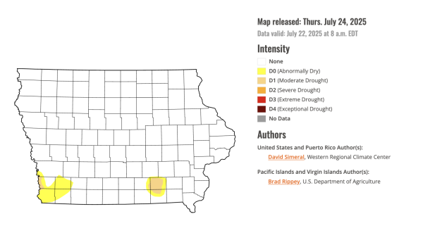
Drought conditions returned this year after an unseasonably dry beginning of the summer season — even causing some lower corn early harvest totals — but recent storms relieved Iowa’s dryness.
In June, large portions of Iowa were abnormally dry, including a portion of Story County, with little rainfall. But things got wetter in Iowa since then, with heavy rains and recent storms.
The U.S. Drought Monitor released July 24, a new drought map shows most of Iowa, including Ames, is no longer in a drought. Small portions of southern Iowa remain in a drought.